DJI Mavic, Air and Mini Drones
Friendly, Helpful & Knowledgeable Community
Join Us Now

Reusing waypoint flights

Squidinc

I come from a land “down under”
Premium Pilot
Joined
Jun 8, 2020
Messages
1,669
Reactions
2,300
Age
66
Location
Red Head , NSW, Australia 🇦🇺
Site
youtu.be
I have a waypoint flight saved which I’m intending to use for a number of flights. I noticed today that when my Air 3 flew to the first waypoint to complete the flight it was at least a metre or more different to the saved flight. Is this normal? Is it wind related perhaps? Any way of fixing it, as I need to have each flight the same coordinates?
 
  • Like
Reactions: Jonathan A
I have a waypoint flight saved which I’m intending to use for a number of flights. I noticed today that when my Air 3 flew to the first waypoint to complete the flight it was at least a metre or more different to the saved flight. Is this normal? Is it wind related perhaps? Any way of fixing it, as I need to have each flight the same coordinates?
Can anyone please help?🙏
 
I am looking for the same info. Was intending to do a number of videos on the same path and then blend them into a change of seasons which I hoped would be seamless. As it worked out, instead of our usual 100 inches of snow last winter, we had less than 20 and it fell while I was out of town. Other projects are in mind and I'd like to know the answer to your question too.
 
  • Like
Reactions: Squidinc
I recall seeing a post somewhere that to get excellent repeatability you have to take off from exactly the same spot. I have not tested this myself but if it works it's an easy fix.
 
  • Like
Reactions: Squidinc
I recall seeing a post somewhere that to get excellent repeatability you have to take off from exactly the same spot. I have not tested this myself but if it works it's an easy fix.
Thanks for your advice. In my case I took off from exactly the same spot. Like @JimSteadman I’m endeavouring to blend a number of flights across a period of time. If the flight waypoint paths don’t match at the very least closely, then it’s useless.
 
THIS IS A VERY LONG POST... READ IT IN ITS ENTIRETY TO LEARN ABOUT HOW GPS ACCURACY VARIES DYNAMICALLY, AND HOW TO PLAN A MISSION WITH THE MOST ACCURACY POSSIBLE

____________________________________________

Waypoint coordinates will be no more precise than you experience with RTH without Precision Landing active (which uses the VPS cameras and Optical Flow to maneuver a precise touchdown within a few inches).

With an excellent configuration of satellites and a clear, unobstructed view of the sky, you can expect at best 3ft accuracy from consumer-grade GPS.

As such, getting within a meter of a waypoint's location is excellent, and you can't expect better precision. Random chance may take you closer to the precise location on any particular run, but that's not reliably repeatable.

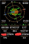
On android, I use an app called GPS Status and Toolbox to determine things like current accuracy in my location. It calculates the DOP from the current satellite configuration, and converts this to an estimated accuracy. I've found it to be a pretty good indicator of what sort of GPS precision I can expect when I fly.

Right now, were I to fly and use simple GPS-based RTH, I would expect the drone to come back and land within a ~12 ft radius circle centered on the Home Point location:

1000017715.jpg

Waypoint accuracy would be the same if I were to fly a mission right now.

Note the satellite locations and distribution in the sky (the little squares, circles, x's in the big horizon circle above). They are poorly distributed right now, hence the up to 12ft (average!) error.

If I needed the best possible accuracy, I could wait for a better distribution of sats, getting the error down as low as 3-4ft.

The positions and movement of the satellites is known and predictable (GPS wouldn't work otherwise). There are on line tools (GNSS Mission Planning, and Google it) that can be used to predict the error in the future at some date/time, so for planning a waypoint flight to be as accurate as possible, you can determine when to fly the mission and get the most accurate result.
 
  • Like
Reactions: Squidinc
To add more to this topic, please check out similar threads at the bottom. "Altitude not repeating on saved hyper lapse waypoint mission – Air 3
You will see there that I flew four times from the same exact spot, all within a timeframe of one hour, landing and taking off from the same spot and only exchanging batteries and changing a parameter for the interval in my Hyperlapse.

My initial saved altitude was 300 feet and the mission was saved and when repeated three times following that you will see in the post it went to three different altitudes going lower and lower each time until the last one at 217 feet.

Working with the DJI techs, they requested I send the incident recorded mission along with the screen, recordings, and flight logs for them to review. I did not have screen recordings for those missions so I had to do it all over again and include screen recordings. Once I completed all of that and sent it to them, they reviewed it and asked me to send them the aircraft. This has only been two days ago, so I will let you know how this turns out.
 
  • Like
Reactions: Squidinc
THIS IS A VERY LONG POST... READ IT IN ITS ENTIRETY TO LEARN ABOUT HOW GPS ACCURACY VARIES DYNAMICALLY, AND HOW TO PLAN A MISSION WITH THE MOST ACCURACY POSSIBLE

____________________________________________

Waypoint coordinates will be no more precise than you experience with RTH without Precision Landing active (which uses the VPS cameras and Optical Flow to maneuver a precise touchdown within a few inches).

With an excellent configuration of satellites and a clear, unobstructed view of the sky, you can expect at best 3ft accuracy from consumer-grade GPS.

As such, getting within a meter of a waypoint's location is excellent, and you can't expect better precision. Random chance may take you closer to the precise location on any particular run, but that's not reliably repeatable.

On android, I use an app called GPS Status and Toolbox to determine things like current accuracy in my location. It calculates the DOP from the current satellite configuration, and converts this to an estimated accuracy. I've found it to be a pretty good indicator of what sort of GPS precision I can expect when I fly.

Right now, were I to fly and use simple GPS-based RTH, I would expect the drone to come back and land within a ~12 ft radius circle centered on the Home Point location:

View attachment 174767

Waypoint accuracy would be the same if I were to fly a mission right now.

Note the satellite locations and distribution in the sky (the little squares, circles, x's in the big horizon circle above). They are poorly distributed right now, hence the up to 12ft (average!) error.

If I needed the best possible accuracy, I could wait for a better distribution of sats, getting the error down as low as 3-4ft.

The positions and movement of the satellites is known and predictable (GPS wouldn't work otherwise). There are on line tools (GNSS Mission Planning, and Google it) that can be used to predict the error in the future at some date/time, so for planning a waypoint flight to be as accurate as possible, you can determine when to fly the mission and get the most accurate result.
Thanks @Droning on and on... so much for your detailed help and links. I clearly now have a better understanding of what is realistically possible in replicating a number of waypoint flights. Cheers 👍🏻
 
THIS IS A VERY LONG POST... READ IT IN ITS ENTIRETY TO LEARN ABOUT HOW GPS ACCURACY VARIES DYNAMICALLY, AND HOW TO PLAN A MISSION WITH THE MOST ACCURACY POSSIBLE

____________________________________________

Waypoint coordinates will be no more precise than you experience with RTH without Precision Landing active (which uses the VPS cameras and Optical Flow to maneuver a precise touchdown within a few inches).

With an excellent configuration of satellites and a clear, unobstructed view of the sky, you can expect at best 3ft accuracy from consumer-grade GPS.

As such, getting within a meter of a waypoint's location is excellent, and you can't expect better precision. Random chance may take you closer to the precise location on any particular run, but that's not reliably repeatable.

On android, I use an app called GPS Status and Toolbox to determine things like current accuracy in my location. It calculates the DOP from the current satellite configuration, and converts this to an estimated accuracy. I've found it to be a pretty good indicator of what sort of GPS precision I can expect when I fly.

Right now, were I to fly and use simple GPS-based RTH, I would expect the drone to come back and land within a ~12 ft radius circle centered on the Home Point location:

View attachment 174767

Waypoint accuracy would be the same if I were to fly a mission right now.

Note the satellite locations and distribution in the sky (the little squares, circles, x's in the big horizon circle above). They are poorly distributed right now, hence the up to 12ft (average!) error.

If I needed the best possible accuracy, I could wait for a better distribution of sats, getting the error down as low as 3-4ft.

The positions and movement of the satellites is known and predictable (GPS wouldn't work otherwise). There are on line tools (GNSS Mission Planning, and Google it) that can be used to predict the error in the future at some date/time, so for planning a waypoint flight to be as accurate as possible, you can determine when to fly the mission and get the most accurate result.
Thanks @Droning on and on... so much for your detailed help and links. I clearly now have a better understanding of what is realistically possible in replicating a number of waypoint flights. Cheers 👍🏻
To add more to this topic, please check out similar threads at the bottom. "Altitude not repeating on saved hyper lapse waypoint mission – Air 3
You will see there that I flew four times from the same exact spot, all within a timeframe of one hour, landing and taking off from the same spot and only exchanging batteries and changing a parameter for the interval in my Hyperlapse.

My initial saved altitude was 300 feet and the mission was saved and when repeated three times following that you will see in the post it went to three different altitudes going lower and lower each time until the last one at 217 feet.

Working with the DJI techs, they requested I send the incident recorded mission along with the screen, recordings, and flight logs for them to review. I did not have screen recordings for those missions so I had to do it all over again and include screen recordings. Once I completed all of that and sent it to them, they reviewed it and asked me to send them the aircraft. This has only been two days ago, so I will let you know how this turns out.
Thanks @KenG Will be interested to hear what DJI come back with.
 
To add more to this topic, please check out similar threads at the bottom. "Altitude not repeating on saved hyper lapse waypoint mission – Air 3
You will see there that I flew four times from the same exact spot, all within a timeframe of one hour, landing and taking off from the same spot and only exchanging batteries and changing a parameter for the interval in my Hyperlapse.

I'm following that discussion, and something else is afoot with the Hyperlapse altitude errors. While GPS vertical accuracy is considerably worse than horizontal, the behavior and errors being seen with these Hyperlapse flights is far worse than any normal GPS inaccuracy.

Also, IIRC the error seems to add in the same direction from waypoint to waypoint (i.e. negative)... If it was simply a really bad day with a huge VDOP, you'd expect a more random mix of errors.
Just received email from DJI. Remember they have my Air 3 they requested I return to them after I sent them video and screen recordings of aircraft not repeating altitudes from saved waypoint hyperlapse. Their findings are a new core board module is needed and they are replacing it under warranty to return to me within the next few days. Once I receive it and try a few flights, I will let everyone know.
 
  • Like
Reactions: Squidinc
Just received email from DJI. Remember they have my Air 3 they requested I return to them after I sent them video and screen recordings of aircraft not repeating altitudes from saved waypoint hyperlapse. Their findings are a new core board module is needed and they are replacing it under warranty to return to me within the next few days. Once I receive it and try a few flights, I will let everyone know.

I'm skeptical this will fix it, given how many other people are experiencing the same issue.
 
Just received email from DJI. Remember they have my Air 3 they requested I return to them after I sent them video and screen recordings of aircraft not repeating altitudes from saved waypoint hyperlapse. Their findings are a new core board module is needed and they are replacing it under warranty to return to me within the next few days. Once I receive it and try a few flights, I will let everyone know.
@KenG That’s great news! Thanks for sharing. I think we both knew that this wasn’t “pilot error”. Please keep us posted on your testing. Meanwhile I’ve bought a rain jacket & wet suit from @Phantomrain.org 🤣👍🏻
 
Lycus Tech Mavic Air 3 Case

DJI Drone Deals

Forum statistics

Threads
131,543
Messages
1,564,049
Members
160,441
Latest member
dozerdan